Centre for Advocacy and Research (CFAR) (2026) SFD (Lite) Report - Jatni
Jatni is located approximately 22 km southwest of Bhubaneswar, the state capital of Odisha. The town serves as a major railway logistics and transport hub, which significantly influences its socio-economic development and spatial growth and has established it as an important workforce centre. Geographically, Jatni is positioned at 20°10′ N latitude and 85°42′ E longitude, situated on generally flat terrain with minor elevation variations, averaging […]
Online since: 05.06.2026
Views: 0
Downloads: 169
Centre for Advocacy and Research (CFAR) (2026) SFD (Lite) Report - Khordha
Khordha, located in eastern Odisha, serves as the district headquarters. The town is situated strategically along NH-16, linking Bhubaneswar and Berhampur. This corridor has strengthened the town’s administrative role, economic activities, and regional connectivity. Geographically, the town lies at 20°15′ N latitude and 85°37′ E longitude. The climate is tropical monsoon, with temperatures ranging from 10°C in winter to 42°C in summer and an average […]
Online since: 05.06.2026
Views: 0
Downloads: 189
Centre for Advocacy and Research (CFAR) (2026) SFD (Lite) Report - Dausa City
Dausa City is located in eastern Rajasthan, approximately 55 km east of Jaipur along National Highway 21, positioning it as an important regional service centre and transit-linked urban node. Its strategic location along this mobility corridor has facilitated its role as a hub for trade, agro-based activities, local markets, and mineral-linked industries, while also supporting daily commuting and regional economic integration. Geographically, the city lies […]
Online since: 03.06.2026
Views: 0
Downloads: 165
Centre for Advocacy and Research (CFAR) (2026) SFD (Lite) Report - Chaksu Muncipality
Chaksu municipality is situated approximately 35 km south of Jaipur, along National Highway 52 and State Highway 2. Strategic location and connectivity through road and rail corridors have supported its gradual emergence as a satellite town of Jaipur, integrating it into the broader transport and economic networks of the Jaipur district. Geographically, the town lies between 26°46′ N to 27°01′ N latitude and 75°37′ E […]
Online since: 02.06.2026
Views: 0
Downloads: 1065
IRC-WASH, Water for People, PSI, PRO-WASH & SCALE (Editor: Jess MacArthur) (2025) Market Based-Sanitation Course - IRC WASH
Market-Based Sanitation (MBS) sanitation programming approach which addresses market challenges to create sustainable sanitation services for all. This PDF-version includes both parts of a two-part online course from IRC-WASH's WASH Systems academy. The course integrates the latest global thinking and was developed by IRC WASH with support from USAID Transform WASH in collaboration with Water For People and Population Services International (PSI). In 2024, […]
Online since: 28.05.2026
Views: 0
Downloads: 190
CWIS-FSM Support Cell, DPHE (2023) SFD (Lite) Report - Ishwardi Municipality (vn 2023)
Ishwardi Municipality is situated in the Ishwardi Upazila of Pabna District, under Rajshahi Division. It is located 27 km away from Pabna City centre. The geographical coordinates of Ishwardi are 24° 08' 60.00" N and 89° 04' 0.12" E. Ishwardi Paurashava is situated in the Ishwardi Sub-District. Ishwardi Upazila is bordered on the north by Lalpur and Baraigram Upazilas, on the south by Kushtia Sadar […]
Online since: 08.05.2026
Views: 0
Downloads: 244
CWIS-FSM Support Cell, DPHE (2023) SFD (Lite) Report - Kamalganj Municipality
Kamalganj Municipality is situated within the Kamalganj Sub-District (Upazila) in Maulvibazar District (Zila), which is under Sylhet Division. The geographical coordinates of Kamalganj (upazila) are between 24°08' and 24°27' north latitudes and between 91°46' and 91°50' east longitudes. It is bounded by Rajnagar upazila on the north, Tripura state of India on the south, Kulaura upazila and Assam state of […]
Online since: 06.05.2026
Views: 0
Downloads: 265
Environment and Public Health Organization (ENPHO) (2024) SFD (Level 2) Report - Triyuga Municipality
Triyuga Municipality was declared as municipality in 2016. The municipality is located in Udayapur District, Koshi Province. The municipality is divided into sixteen political wards. The municipality has total 102,725 population with 48,462 males and 54,262 females (Census 2021, n.d.). Out of total wards, ward number 11 has the largest population (11,400) while ward […]
Online since: 05.05.2026
Views: 0
Downloads: 254
Environment and Public Health Organization (ENPHO) (2023) SFD (Level 2) Report - Neelakantha Municipality
Neelakantha municipality is located in the Dhading district of Nepal (Bagmati Province). Neelkantha was established on 8th May 2014 and restructured on 10th March 2017. The municipality is divided into 14 political wards. The municipality has a total population of 58,828 with 27,365 males and 31,463 females (Census 2021, n.d.). Out of total wards, ward number 3 […]
Online since: 05.05.2026
Views: 0
Downloads: 263
Environment and Public Health Organization (ENPHO) (2024) SFD (Level 2) Report - Pokhara Metropolitan City
Pokhara Metropolitan City was declared as municipality on 10th March 2017. It is in Kaski District, Gandaki Province in Nepal. It is divided into 33 political wards. The municipality has a total population of 513,504 with 247,495 males and 266,009 females (Census 2021, n.d.) . Out of total wards, ward number 17 has the largest population (46,005) […]
Online since: 05.05.2026
Views: 0
Downloads: 283
CWIS-FSM Support Cell, DPHE (2023) SFD (Lite) Report - Hakimpur Municipality
Hakimpur Municipality is located within the Hakimpur Sub-District (Upazila) situated in the Dinajpur District (Zila) under Rangpur Division. The geographical coordinates of Hakimpur are 25°16'59.88"N and 89°01'0.12"E.1 It is bordered on the north by the Upazilas of Nawabganj (dinajpur) and Birampur, on the south by the Upazila of Panchbibi, on the east by the Upazila of Ghoraghat, and on the […]
Online since: 24.04.2026
Views: 0
Downloads: 284
CWIS-FSM Support Cell, DPHE (2023) SFD (Lite) Report - Muktagacha Municipality
Muktagacha Municipality is located within the Muktagacha Sub-District (Upazila) situated in the Mymensingh District (Zila) under Mymensingh Division. The geographical coordinates of Muktagacha are 24° 75' N and 90° 27' E longitude. It is bordered on the north by the Upazilas of Mymensingh Sadar and Jamalpur Sadar, on the south by the Upazila of Fulbaria, on the east by the Upazilas of Madhupur, and on […]
Online since: 24.04.2026
Views: 0
Downloads: 281
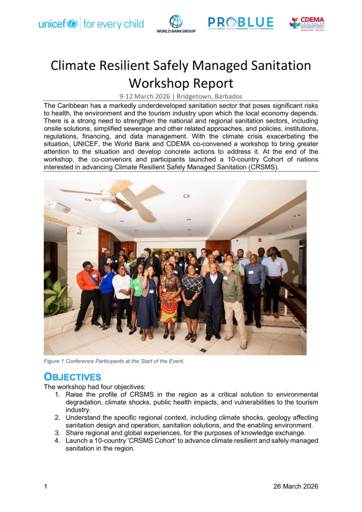
CRS Coalition (2026) Climate Resilient Safely Managed Sanitation Workshop Report
The Caribbean has a markedly underdeveloped sanitation sector that poses significant risks to health, the environment and the tourism industry upon which the local economy depends. There is a strong need to strengthen the national and regional sanitation sectors, including onsite solutions, simplified sewerage and other related approaches, and policies, institutions, regulations, financing, and data management. With the climate crisis exacerbating the situation, UNICEF, the […]
Online since: 24.04.2026
Views: 0
Downloads: 290
City of uMhlatuze (2025) SFD (Level 1) Report - City of uMhlatuze
The City of uMhlathuze (CoU) Local Municipality is comprised of Richards Bay, Empangeni, Vulindlela, eSikhaleni (Esikhawini), Nseleni, Felixton, Ngwelezane and four Traditional Authority Areas. The 2022 national census (Stats SA) indicates a population of 412,075 people in 100,441 households. Most of the population (58%) within the municipality resides in tribal or traditional areas, while 39% reside in urban areas and the remaining 3% reside on […]
Online since: 23.04.2026
Views: 0
Downloads: 303
Environment and Public Health Organization (ENPHO) (2023) SFD (Level 2) Report - Besishahar Municipality
Besishahar Municipality, located in the Lamjung district of Nepal's Gandaki Province, was formed through the merger of several Village Development Committees (VDCs). According to the 2021 National Population and Housing Census, Besishahar Municipality has a population of 38,232 individuals residing in 11,038 households, with males 46.8% and females 53.2%. This section provides a quick summary of […]
Online since: 23.04.2026
Views: 0
Downloads: 250
M. K. Raina (2026) Samman - A film on sanitation workers safety and dignity
Samman is a powerful and deeply moving film directed by the celebrated Theatre and Film Actor and Director M. K. Raina. The film takes viewers into the often unseen world of sanitation workers in India, bringing to light the harsh realities of their work and the dangerous conditions they face every day. Despite legal safeguards such as the Prohibition of Employment as Manual Scavengers and their […]
Online since: 10.04.2026
Views: 0
Downloads: 0
Surendra K Pradhan, Helvi Heinonen-Tanski, Alisa Puga Keesey (2026) Human urine fertilizer business – constraints and possibilities
Human urine is rich in essential plant nutrients nitrogen (N), phosphorus (P), and potassium (K). One person produces about 500 L of urine per year, corresponding to an estimated 2 kg of N, 0.3 kg of P, and 1 kg of K. These nutrients are sufficient to fertilize 0.4 hectares of land, which can produce some 270 kg of rice or 180 kg of wheat, […]

Online since: 10.04.2026
Views: 0
Downloads: 289
Oxfam (2025) WASH Climate Change Adaptation
Climate change is already having significant negative effects on the lives and livelihoods of people living in countries affected by conflicts and disasters. It is also making the provision of humanitarian support more difficult. This situation can be expected to get worse in the coming years. The humanitarian Water, Sanitation and Hygiene (WASH) sector faces particular risks and challenges. The increased temperatures resulting from global […]
Online since: 10.04.2026
Views: 0
Downloads: 3147
Oxfam (2025) WASH Adaptation au changement climatique
Le changement climatique a déjà des répercussions négatives importantes sur la vie et les moyens de subsistance des populations vivant dans des pays touchés par des conflits et des catastrophes. Il complique également la fourniture de l'aide humanitaire. Cette situation devrait s'aggraver dans les années à venir. Le secteur humanitaire de l'eau, de l'assainissement et de l'hygiène (WASH) est confronté à des risques et à […]
Online since: 09.04.2026
Views: 0
Downloads: 2864
GIZ Staff Initiative MenstruAction (2026) MenstruAction: From Enthusiasm to Action Make menstrual health and hygiene a global priority!
This brochure illustrates the journey of the GIZ staff initiative MenstruAction from its beginnings until today. MHH has proven to be an intersectoral topic that needs cross-fertilization between a range of approaches and perspectives including the involvement of colleagues from programmes on sexual and reproductive health and rights, school health, WASH and gender equality and empowerment, education, values and religion as well as waste management […]
Online since: 07.04.2026
Views: 0
Downloads: 411