Centre for Advocacy and Research (CFAR) (2026) SFD (Lite) Report - Jatni
Jatni is located approximately 22 km southwest of Bhubaneswar, the state capital of Odisha. The town serves as a major railway logistics and transport hub, which significantly influences its socio-economic development and spatial growth and has established it as an important workforce centre. Geographically, Jatni is positioned at 20°10′ N latitude and 85°42′ E longitude, situated on generally flat terrain with minor elevation variations, averaging […]
Online since: 05.06.2026
Views: 0
Downloads: 179
Centre for Advocacy and Research (CFAR) (2026) SFD (Lite) Report - Khordha
Khordha, located in eastern Odisha, serves as the district headquarters. The town is situated strategically along NH-16, linking Bhubaneswar and Berhampur. This corridor has strengthened the town’s administrative role, economic activities, and regional connectivity. Geographically, the town lies at 20°15′ N latitude and 85°37′ E longitude. The climate is tropical monsoon, with temperatures ranging from 10°C in winter to 42°C in summer and an average […]
Online since: 05.06.2026
Views: 0
Downloads: 200
Centre for Advocacy and Research (CFAR) (2026) SFD (Lite) Report - Dausa City
Dausa City is located in eastern Rajasthan, approximately 55 km east of Jaipur along National Highway 21, positioning it as an important regional service centre and transit-linked urban node. Its strategic location along this mobility corridor has facilitated its role as a hub for trade, agro-based activities, local markets, and mineral-linked industries, while also supporting daily commuting and regional economic integration. Geographically, the city lies […]
Online since: 03.06.2026
Views: 0
Downloads: 176
Centre for Advocacy and Research (CFAR) (2026) SFD (Lite) Report - Chaksu Muncipality
Chaksu municipality is situated approximately 35 km south of Jaipur, along National Highway 52 and State Highway 2. Strategic location and connectivity through road and rail corridors have supported its gradual emergence as a satellite town of Jaipur, integrating it into the broader transport and economic networks of the Jaipur district. Geographically, the town lies between 26°46′ N to 27°01′ N latitude and 75°37′ E […]
Online since: 02.06.2026
Views: 0
Downloads: 1072
Environment and Public Health Organization (ENPHO) (2023) SFD (Level 2) Report - Neelakantha Municipality
Neelakantha municipality is located in the Dhading district of Nepal (Bagmati Province). Neelkantha was established on 8th May 2014 and restructured on 10th March 2017. The municipality is divided into 14 political wards. The municipality has a total population of 58,828 with 27,365 males and 31,463 females (Census 2021, n.d.). Out of total wards, ward number 3 […]
Online since: 05.05.2026
Views: 0
Downloads: 272
City of uMhlatuze (2025) SFD (Level 1) Report - City of uMhlatuze
The City of uMhlathuze (CoU) Local Municipality is comprised of Richards Bay, Empangeni, Vulindlela, eSikhaleni (Esikhawini), Nseleni, Felixton, Ngwelezane and four Traditional Authority Areas. The 2022 national census (Stats SA) indicates a population of 412,075 people in 100,441 households. Most of the population (58%) within the municipality resides in tribal or traditional areas, while 39% reside in urban areas and the remaining 3% reside on […]
Online since: 23.04.2026
Views: 0
Downloads: 318
Environment and Public Health Organization (ENPHO) (2023) SFD (Level 2) Report - Besishahar Municipality
Besishahar Municipality, located in the Lamjung district of Nepal's Gandaki Province, was formed through the merger of several Village Development Committees (VDCs). According to the 2021 National Population and Housing Census, Besishahar Municipality has a population of 38,232 individuals residing in 11,038 households, with males 46.8% and females 53.2%. This section provides a quick summary of […]
Online since: 23.04.2026
Views: 0
Downloads: 258
Environment and Public Health Organization (ENPHO) (2023) SFD (Level 2) Report - Bidur Municipality
Bidur, a municipality is situated in Nuwakot district of Bagmati Province, Nepal which is located at 69 km northwest of Kathmandu Valley. It comprises of 13 political wards and spread over an area of 130.01 square kilometres consisting of plains and hilly plateaus (Bidur Municipality, 2024). It has a total population of 59,227 individuals across 15,234 households (NSO,2021). It has subtropics and sub-humid climate, with […]
Online since: 09.01.2026
Views: 0
Downloads: 520
George Local Municipality (GLM) (2024) SFD (Level 1) Report - George Local Municipality
George Local Municipality (LM) is situated in the Garden Route District Municipality in the Western Cape Province of South Africa. It has a land area of 5,191 km2 that covers the Southern Cape and Little Karoo Regions of the Western Cape (George Municipality, 2025b). The municipality has a population of 294,929 people in 85,931 households (Stats SA, 2022). George LM has 28 municipal wards. 99% of households […]

Online since: 09.12.2025
Views: 0
Downloads: 603
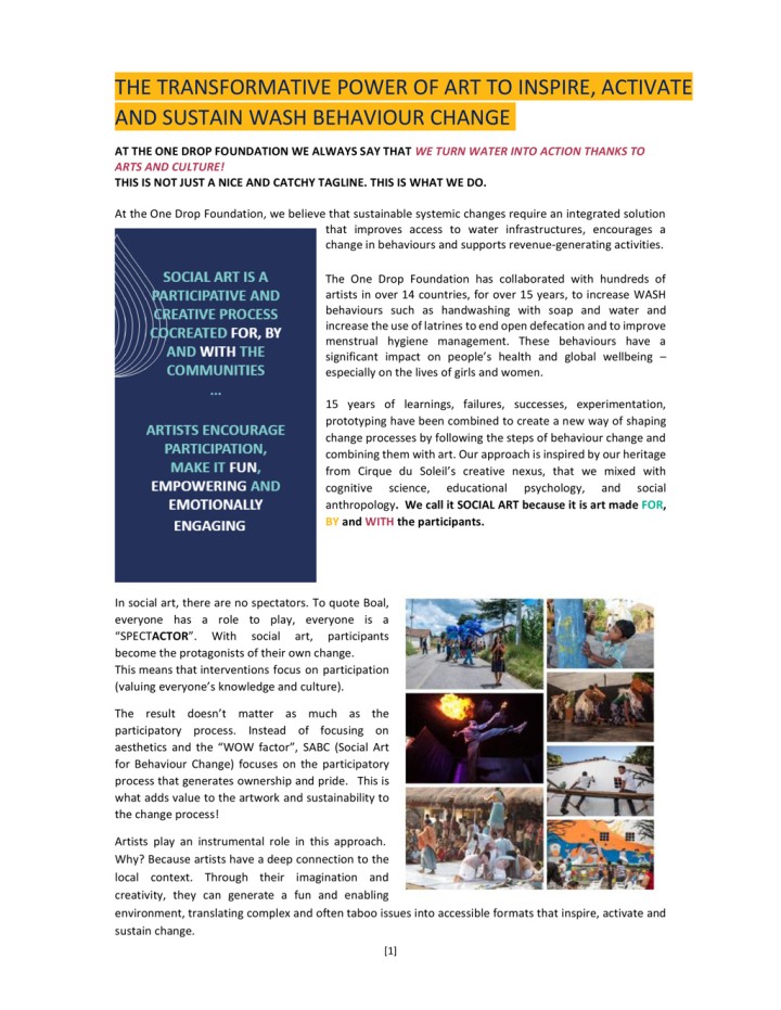
One Drop Foundation () The Transformative Power of Art to Inspire, Activate and Sustain WASH Behaviour Change
At the One Drop Foundation, we believe that sustainable systemic changes require an integrated solution that improves access to water infrastructures, encourages a change in behaviours and supports revenue-generating activities. The One Drop Foundation has collaborated with hundreds of artists in over 14 countries, for over 15 years, to increase WASH behaviours such as handwashing with soap and water and increase the use of latrines […]
Online since: 08.07.2025
Views: 53
Downloads: 636
John T. Trimmer, Joyce Kisiangani, Rachel Peletz, Kara Stuart, Prince Antwi-Agyei, Jeff Albert, Ranjiv Khush, and Caroline Delaire (2022) The Impact of Pro-Poor Sanitation Subsidies in Open Defecation-Free Communities: A Randomized,Controlled Trial in Rural Ghana
According to the World Health Organization/United Nations International Children’s Fund Joint Monitoring Program, 494 million people practice open defecation globally. After achieving open defecation-free (ODF) status through efforts such as Community-Led Total Sanitation (CLTS), communities (particularly vulnerable households) may revert to open defecation, especially when toilet collapse is common and durable toilets are unaffordable. Accordingly, there is increasing interest in pro-poor sanitation subsidies. This study, produced […]
Online since: 04.04.2024
Views: 539
Downloads: 383
USAID (2018) An examination of CLTS’s contributions toward universal sanitation
This desk review examines the refereed and gray literature on Community Led Total Sanitation (CLTS), with the central objective of assessing the knowledge base on best practices and identifying evidence gaps to inform the project’s research agenda (to generate findings that improve policy and practice). The review offers a description of the CLTS intervention, tracing its evolution in theory and practice from Southeast Asia to its […]
Online since: 28.03.2024
Views: 487
Downloads: 821
Rishi Agarwal, Subhash Chennuri, and Aaron Mihaly, FSG (2018) Scaling Market-Based Sanitation Desk Review on Market-Based Rural Sanitation Development Programs
This desk review from the USAID/WASHPaLS project investigates the current state of knowledge in market-based sanitation (MBS) and establishes a framework to analyze, design, and improve MBS interventions. This report is based on a survey of approximately 600 documents on MBS, in-depth research into 13 MBS intervention case studies across the global south, and interviews with sector experts and program personnel. This review offers a framework […]
Online since: 28.03.2024
Views: 427
Downloads: 372
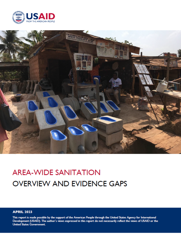
Crystal Huang, Steven Walker, Adrian Brillantes-Stepper, Carolien van der Voorden (2023) Area-wide sanitation Overview and evidence gaps
The last few decades have witnessed substantial gains in access to sanitation, as nearly 2.4 billion people gained access to improved toilets and open defecation (OD) rates fell 12 percentage-points globally (from 21% to 9%) between 2000 and 2020. Despite this progress, many countries are off track to meet their sustainable development goal (SDG) 6.2 targets. To reach these targets by 2030, a concerted effort […]
Online since: 26.03.2024
Views: 453
Downloads: 678
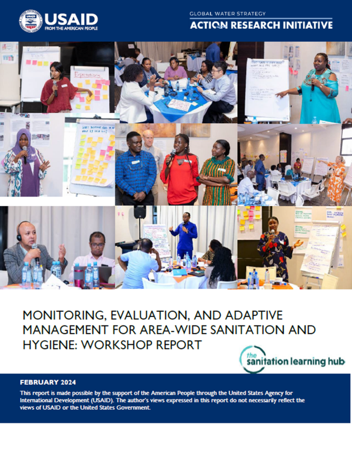
USAID (2024) Monitoring, evaluation, and adaptive management for area-wide sanitation and hygiene: Workshop report
Monitoring and evaluation (M&E) is essential to understanding the barriers, successes, and progress made toward achieving area-wide sanitation and hygiene outcomes. However, M&E can be challenging to undertake, given significant and competing demands on limited local government resources and capacities. USAID’s WASHPaLS #2 area-wide sanitation (AWS) desk review identified significant knowledge gaps around effective practices, processes, and systems for M&E and adaptive management of area-wide […]
Online since: 26.03.2024
Views: 454
Downloads: 413
GFA Consulting Group GmbH (2018) SFD (Lite) Report - Dodoma City, Tanzania
Dodoma City Council is located at the south-eastern end of the Tanzania Central Plateau at an elevation of 1,200 metres above sea level with coordinates 6°10′23″S 35°44′31″E. The city council is divided into 41 wards and Mtaas (streets) and covers an area of about to 2,769 sq. km. The 41 wards are grouped into four divisions. Currently, the population of Dodoma Municipal is estimated to […]
Online since: 02.02.2024
Views: 691
Downloads: 920
ENPHO (2023) SFD (level 2) Report - Tansen Municipality, Nepal
Tansen Municipality is one of the oldest municipalities in the country, established in March 1950. It is located in Palpa District, Lumbini Province. The Municipality has a total of 14 political wards. Tansen Municipality occupies an area of 109.8 square kilometres. The municipality has a total population of 50,792 with 23,414 males and 27,378 females (Census 2021, n.d.). Palpa District was declared as an open defecation […]
Online since: 21.11.2023
Views: 1083
Downloads: 435
ENPHO (2023) SFD (level 2) Report - Birgunj Metropolitan City, Nepal
Birgunj Metropolitan City is located in the Parsa District, Madhesh Province of Nepal, near the southern border with India. Birgunj Metropolitan City was officially formed on 14 April 2017. It was created by merging several local administrative units, including Birgunj Municipality, Pokhariya Municipality, and Adarsh Kotwal Rural Municipality. The total area of Birgunj Metropolitan City is approximately 44.56 square kilometres (17.21 square miles). This area […]
Online since: 02.11.2023
Views: 1267
Downloads: 2382
ENPHO (2023) SFD (level 2) Report - Sunwal Municipality, Nepal
Sunwal Municipality is situated in Nawalparasi District of Lumbini Province in the southern region of Nepal. It was established on May 18, 2014 by merging the Village Development Committees (VDCs), Swathi and Sunwal. On March 10, 2017, it was reformed by merging the Ramnagar area and ward 6 of Dhurkot VDC with the already-existing Sunwal Municipality. It is divided into 13 wards.As per the national […]
Online since: 23.10.2023
Views: 1157
Downloads: 702
ENPHO (2023) SFD (level 2) Report - Kolhabi Municipality, Nepal
Kolhabi Municipality is situated in Bara District of Madhesh Province in the southern region of Nepal. It is divided into 11 wards and covers an area of 157.40 sq. km. It was restructured by merging the already-existing Kolhabi, Sapahi, Prasauna, Kakadi, Amab, Bachhanpurwa, Rampurwa Village Development Committeees (VDCs) and some wards from VDCs Sinhasani (wards 1 and 2), Haraiya (ward 6), Karaiya (ward 8) and […]
Online since: 06.10.2023
Views: 913
Downloads: 1896